
Ebla’s Landscape – Tell Mardikh/Ebla and its surroundings
Tell Mardikh/Ebla (35°47’59.84″N, 36°47’53.10″E), located 55 km south-west of Aleppo, is the ancient Bronze Age city of Ebla, one of the great urban centres of the ancient Near East; royal archives (originally) consisting of more than 5,000 cuneiform tablets dating from the 24th century BC have been found there. 47 years of archaeological research (1964-2010) at the site uncovered the outstanding remains of a 60-hectare urban centre, destroyed three times and rebuilt twice between c. 2700 BC and 1600 BC (Early to Middle Bronze Age).
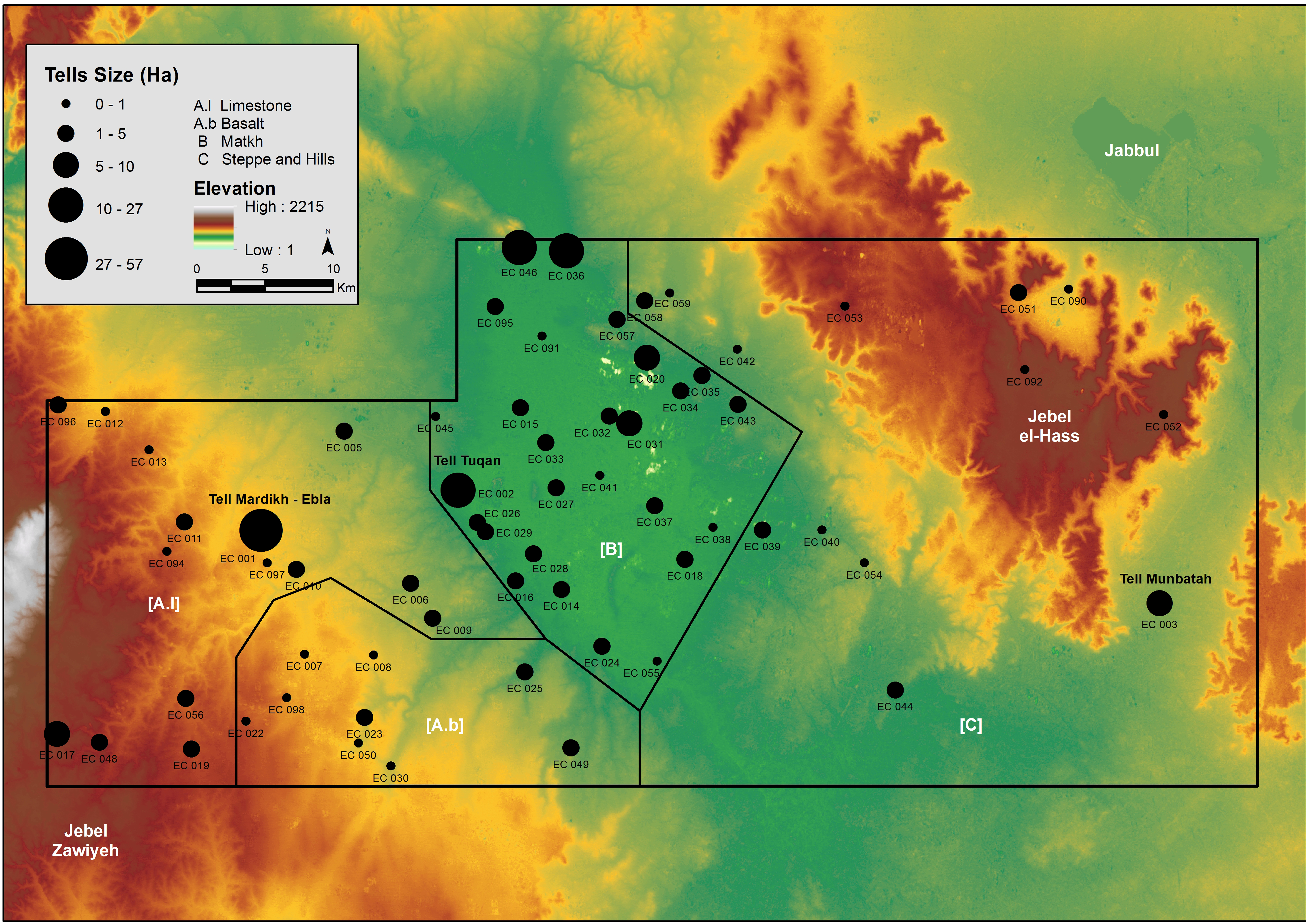
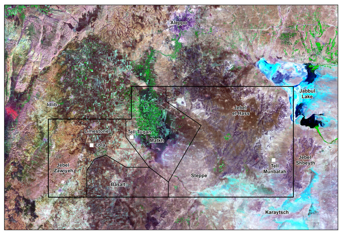
The archaeological landscape around Ebla investigated by the ECP covers an area of approximately 3500 km2, encompassing three ecological zones, with 114 documented sites dating from the Early Bronze Age (EBA) to the end of the Iron Age (IA). The three main ecological zones are: 1) the limestone and basalt foothills around Tell Mardikh/Ebla (Area A); 2) the Matkh depression (Area B); 3) the steppe region to the east, up to the el-Hass and Shbeyt ranges (Area C).
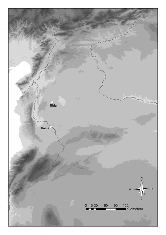
Map of Northern Levant showing the geographical position of Tell Mardikh/Ebla

Aerial detailed photo of Tell Mardikh/Ebla in a satellite imagery Cartosat-1 (September 27, 2009); 2.5 m resolution. ©MAIS
The results of the ECP analysis suggest a general intensification in the number and size of settlements from around the mid-3rd millennium BC, when nearly all the areas with a potential for agro-pastoral exploitation were occupied, including the arid region of the Syrian steppe. During this timespan, Ebla developed from a powerful city-state to the capital of a territorial state (EB IVA, c. 2700-2300 BC), extending its influence over an extensive area ranging from the Middle Euphrates to the Hama region. The disruption of the EB IVA system following the destruction of the “First Ebla” (c. 2300 BC) did not result in a generalized crisis; conversely, the uninterrupted occupation of several sites and the strong homogeneity of the material culture suggest aspects of marked continuity with the previous period. A very different settlement pattern from that of the Early Bronze Age seems to characterize the Middle Bronze Age (MBA, 2000-1600 BC), with widespread urbanization and the emergence of ever larger centres, strangely located quite close to one another. These apparent dissimilarities in settlement patterns, reflecting the quite different political and administrative organization of the Ebla territory during the Middle Bronze Age, remain to be explored. Similarly, the general settlement crises that affected the region during the Late Bronze Age (LBA, c. 1600-1200 BC) following the destruction of the “Third Ebla” need to be studied analytically. While Ebla progressively became a rural settlement during the Late Bronze Age and the Iron Age (IA, c. 1200-539 BC), other sites such as Tell Afis (the Biblical Hazrek) emerged as regional centres.
Distribution of sites in the Ebla Chora, showing the three main ecological zones. ©MAIS

Distribution of sites in the Ebla Chora, according to size (EB IV), with an Aster GDem v.2 photograph (2011) in the background. ©MAIS